
Navigate Mountains with 3D Maps
Overview
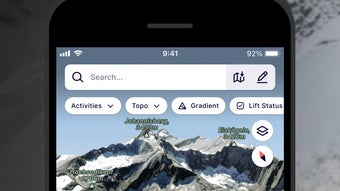
FATMAP: Ski Hike Bike is a freemium desktop and mobile application designed for outdoor enthusiasts navigating mountainous terrain. It serves as a comprehensive travel and navigation tool tailored for skiing, hiking, and mountain biking adventures. The software enables users to visualize their location on detailed 3D maps, offering a realistic preview of landscapes and trail conditions before departure.
This feature is particularly useful for planning routes and assessing terrain difficulty. The app supports both user-generated and community-curated routes, providing access to expertly mapped trails. Users can also check real-time environmental data such as snow conditions and temperature, which enhances safety and preparedness.
Designed for professionals and casual adventurers alike, it caters to those who rely on accurate, up-to-date geographic information during outdoor excursions. The ability to download maps for offline use ensures functionality even in remote areas with no cellular signal. This makes it a reliable companion for extended trips in isolated mountain regions.
The developer did not provide additional system requirements or details about platform-specific behavior.
Key Features & Capabilities
- 3D Terrain Visualization – Offers immersive, high-resolution 3D maps that render mountain landscapes with depth and detail, helping users anticipate trail features and elevation changes.
- Route Planning & Creation – Allows users to design custom routes or follow pre-existing ones from expert contributors and community members.
- Offline Map Access – Maps can be downloaded and accessed without internet connectivity, essential for remote or high-altitude environments.
- Environmental Condition Tracking – Displays real-time data including snow depth, temperature, and weather forecasts for specific trail zones.
- Lift Schedule Integration – Provides lift operating times for nearby resorts, helping users time their return trips efficiently.
- Community-Driven Route Library – Offers a growing collection of user-submitted and verified trails, enhancing route discovery and sharing.
These features support a wide range of real-world scenarios. For instance, a skier planning a backcountry descent can preview elevation profiles and snowpack levels before departure. A hiker preparing for a multi-day trek can download entire region maps in advance and create a step-by-step route.
Mountain bikers can use the app to locate technical sections and avoid hazardous zones. The software also helps prevent getting lost by offering clear visual cues and location tracking, even when signal is unavailable. The developer did not specify performance benchmarks or resource usage during active navigation.
User Interface, Workflow & Performance
The user interface is structured around a map-centric layout, with intuitive navigation tools and layered information displays. Key functions such as route creation, map zooming, and data overlays are accessible through clearly labeled icons and context-sensitive menus. The workflow emphasizes ease of use, allowing users to quickly switch between map views, access trail details, and manage downloaded content.
Interaction is designed for both touch and mouse input, supporting use across desktop and mobile platforms. The app’s performance is consistent with typical GIS-based software, delivering responsive map rendering and smooth panning. However, the developer did not specify resource usage details, including CPU or RAM consumption.
Performance observations are based on general software behavior patterns. Stability appears reliable during standard use, though prolonged offline navigation may affect device battery life. The app supports seamless transitions between online and offline modes, ensuring uninterrupted access to critical data.
Compatibility & System Requirements
FATMAP: Ski Hike Bike is available on multiple platforms, including Windows, Mac, iOS, and Android. The software version is 3.1.1, with an installation size of 1.2 GB. This size reflects the inclusion of high-resolution 3D map data and core navigation tools.
The developer did not specify exact system requirements, including minimum processor speed, RAM, or storage space beyond the total installation footprint. Compatibility information was partially provided. Users are advised to ensure sufficient free storage space, particularly when downloading large topographic maps.
The app is designed to function across different operating systems, though platform-specific behaviors were not detailed. It is recommended to verify available disk space before initiating map downloads to avoid installation failures.
Pros and Cons
Pros
- High-quality 3D maps with realistic terrain visualization
- Supports offline navigation for remote areas
- Extensive library of user and expert-curated routes
- Real-time environmental data for better trip planning
- Free to download and use with core features
- Integrated lift schedules for resort-based travelers
Cons
- Large file size may impact storage on devices with limited space
- Exact system requirements not publicly listed
- Offline maps consume significant storage, requiring careful management
- Performance under heavy load not documented
- Advanced features may require in-app purchases or subscription
FAQ Section
Is FATMAP: Ski Hike Bike available for Windows and Mac?
Yes, the software is compatible with both Windows and Mac operating systems, allowing desktop users to access its full suite of navigation tools.
Can I use FATMAP: Ski Hike Bike offline?
Yes, users can download maps and routes for offline use, enabling full functionality without an internet connection.
Is the software safe to download and install?
FATMAP: Ski Hike Bike is distributed through official channels and is considered secure for users. Always download from verified sources to avoid third-party modifications.
Does the app require a subscription to use all features?
The app is freemium, offering core navigation and map access at no cost. Additional features may require a paid subscription or in-app purchase.
Can I update FATMAP: Ski Hike Bike to the latest version?
Yes, updates are available through official app stores and the developer’s website. The current version is 3.1.1.
Final Thoughts
FATMAP: Ski Hike Bike stands out as a powerful, user-friendly navigation tool for outdoor adventurers. Its 3D mapping capabilities, offline functionality, and access to community-driven routes make it a reliable companion for skiing, hiking, and mountain biking. While the app’s file size may be a concern for users with limited storage, its benefits far outweigh this limitation.
The software is especially valuable for those exploring remote or high-altitude regions where connectivity is unreliable. With its intuitive interface and robust feature set, it delivers a professional-grade experience at no cost. Whether you're a seasoned mountaineer or a weekend explorer, this tool enhances safety, planning, and confidence on the trail.
Download FATMAP Ski Hike Bike now.